Disaster Response
Emergency Mapping
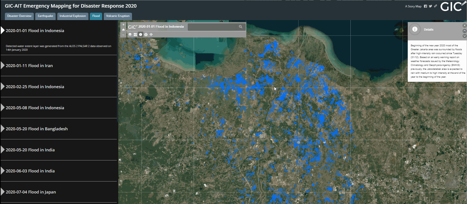
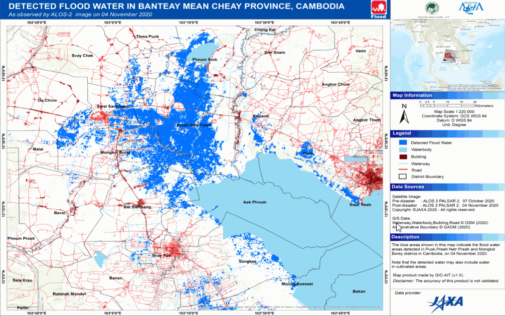 The Geoinformatics Center of the Asian Institute of Technology has been actively involved in disaster response efforts utilizing remote sensing and web-GIS technology as the primary data analysis node (P-DAN) for Sentinel Asia. In my capacity as a research associate in this initiative, I played a significant role in processing satellite data and creating value-added products that could be utilized in a variety of disaster scenarios, such as floods, earthquakes, GLOFs, forest fires, and oil spills. The methods employed in the product generation process included SAR and optical data analysis, interferometric analysis, change detection, and offset tracking.
Links for sample products:
Industrial Explosion Lebanon 2020-08-12 Link.
Earthquake in Tajikistan 2021-07-10 Link.
Flood in Philippines 2020-11-17Link.
Project Manangement for International Disaster Charter (IDC)
 In the event of a significant disaster, the Asian Disaster Reduction Center (ADRC) may escalate an emergency observation request through Sentinel Asia to the International Disaster Charter (IDC). Relevant national agencies or international organizations will nominate a project manager (PM), such as the GIC/AIT, to oversee the process. The PM's primary responsibility is to ensure clear and efficient communication between data providers or partner agencies (PA), value-added companies/resellers, and authorized users (AU). Additionally, the PM will coordinate the activation process, guaranteeing the generated products meet the user's requirements and expectations.
During my tenure at AIT, I was nominated for seven PM roles related to seven significant natural disasters. I successfully managed the communication channels between the value adders, space agencies, and end-members.
In the event of a significant disaster, the Asian Disaster Reduction Center (ADRC) may escalate an emergency observation request through Sentinel Asia to the International Disaster Charter (IDC). Relevant national agencies or international organizations will nominate a project manager (PM), such as the GIC/AIT, to oversee the process. The PM's primary responsibility is to ensure clear and efficient communication between data providers or partner agencies (PA), value-added companies/resellers, and authorized users (AU). Additionally, the PM will coordinate the activation process, guaranteeing the generated products meet the user's requirements and expectations.
During my tenure at AIT, I was nominated for seven PM roles related to seven significant natural disasters. I successfully managed the communication channels between the value adders, space agencies, and end-members.
Links for Activations:
Eruption of Mount Semeru volcano in Indonesia [Activation Id-792] - 25 Dec 2022 Link.
Tropical Storm Nalgae in Philippines [Activation Id-789] - 29 Oct 2022 Link.
Tropical Storm Nori in Thailand :Flood Continuation [Activation Id-739] - 19 Oct 2022 Link
Eruption of Mount Semeru volcano in Indonesia [Activation Id-739] - 07 Dec 2021 Link.
Flooding in Sri Lanka [Activation Id-737] - 12 Nov 2021 Link.
Flood in Philippines [Activation Id-686] - 16 Nov 2020 Link.
Flood and Landslide in Indonesia [Activation Id-638]- 07 Jan 2020 Link.
Web-GIS for Disaster Response
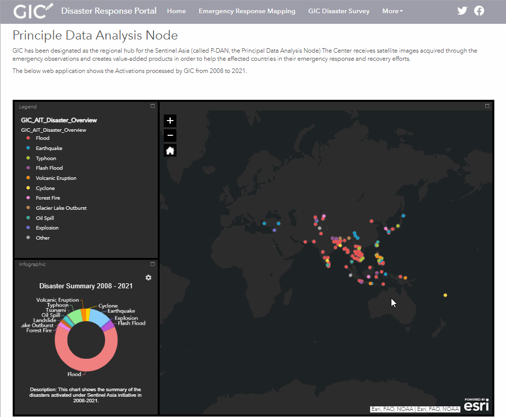 I have created a cutting-edge web-based geographic information system (GIS) platform designed to incorporate satellite-derived disaster-related information for activations initiated via Sentinel Asia. The platform provides users with powerful visualizations of the scope of the disaster, and offers free, open access to data products, thus facilitating improved emergency management activities. This was achieved through the utilization of sophisticated tools such as ArcGIS Online, ArcGIS Enterprise Sites, and ArcGIS API for Python, which enabled the creation of web-maps, web-applications, and sites.
Access the Disaster Response Portal Here!.